
Whakatāneweather
- Updated
- Sunrise:
- Sunset:
14°C
- 16°C12°C
Periods of rain. Gusty northeasterlies.
- 17°C13°C
Periods of rain, with thunderstorms and downpours possible from evening. Gusty northeasterlies.
- 17°C8°C
Showers, some heavy, turning to rain in the evening. Northeasterlies, turning southeasterly in the afternoon.
For more detailed weather information visit MetService.
Marine Recreational Forecasts - Whakatāne
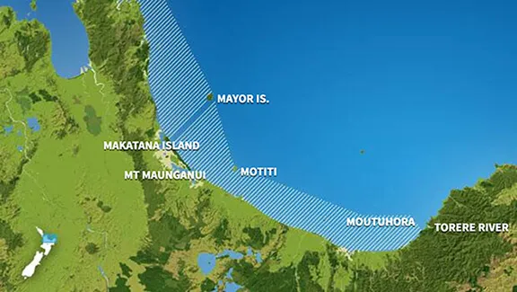
Area Description:
Bay of Plenty
Situation:
A ridge over the country tracks east today while a deepening low and associated fronts approach central and northern Aotearoa New Zealand from the Tasman Sea. Tomorrow the low moves onto central and northern New Zealand while another low moves east past the Far South. On Thursday, a deep and extensive low moves slowly east over the North Island. The low is expected to lie slow moving just northeast of the North Island on Friday. Meanwhile, a ridge of high pressure gradually builds over the lower half of the South Island. On Saturday, the ridge expands further northward as the low continues to drift east away from the country.
Warnings:
Gale warning
Forecasts:
For Bay of Plenty:
Today: Northeast 15 knots, rising to 20 knots early evening, then rising to 25 knots gusting 35 knots late evening. Sea becoming rough late evening. Partly cloudy. Northeast swell 1 metre developing.
Outlook:
For Bay of Plenty:
Wednesday: Northeast 25 knots gusting 35 knots, rising to 35 knots gusting 45 knots in the afternoon. Sea becoming very rough in the afternoon. Poor visibility in rain, very poor visibility in possibly heavy rain from afternoon. Northeast swell 1 metre rising to 2 metres.
Thursday: Northeast 35 knots gusting 45 knots, easing to easterly 15 knots early, then becoming southerly 15 knots later. Showers. Northeast swell 2 metres easing.
Friday: Southerly 15 knots, easing to variable 5 knots for a time. Rain clearing. Northeast swell 1 metre.
Saturday: Southerly 15 knots, easing to variable 5 knots later. Fine. Easterly swell 1 metre dying out.
Swell:
Marine Coastal Forecasts - Plenty
Forecast:
Tuesday: Northeast 15 knots, rising to 25 knots in the evening. Sea becoming rough. Northeast swell 1 metre. Poor visibility in showers.
Outlook:
Outlook following 3 days:
Wednesday: Northeast 25 knots, rising to 35 knots in the afternoon. Sea becoming very rough. Northeast swell rising to 2 metres. Very poor visibility in heavy rain. Thunderstorms possible from afternoon.
Thursday: Northerly 30 knots, becoming southeast 20 knots but northeast 20 knots east of White Island early. Becoming southerly 25 knots everywhere late. Sea rough at times. Moderate northeast swell.
Friday: East of White Island: Southwest 20 knots, turning to northeast 20 knots early. Elsewhere: Southwest 20 knots, easing to variable 10 knots early, then becoming southerly 20 knots later. Moderate northeast swell.
Saturday: Becoming southerly 20 knots early, then easing to variable 10 knots late. Moderate easterly swell.